When the temperatures become hot, water vapor condenses from nearby water sources and around mountain tops, forming dark clouds. These clouds have the potential to culminate in intense electrical storms.

Clearly, it is unwise to continue ascending a summit as the sky pulsates with gigantic bolts of lightning, but sometimes the situation is unavoidable. You may not know that a storm is coming until it crests the summit towards which you may be ascending. In those cases, there are safety measures you can take to protect yourself. Nevertheless, you can reduce your chances of becoming caught off guard by surprise storms as you become a better observer of the sky. Here we’ll help you learn how to become a better observer of the sky, so the next time you are headed to an open area, you can more accurately predict if a thunderstorm is approaching.
To fully appreciate the phenomenon of weather, you must first understand how it happens.
What brings clouds?
The atmosphere is filled with water vapor from the evaporation of water covering the earth’s surface and the ocean. As the water-filled air (or vapor) rises, cools, and condenses (moves from a warm place to a cool place), it forms into water droplets or clouds. A cloud is merely a collection of minute water droplets or ice crystals. Small hygroscopic particles in the sky, such as dust, sea salt, smoke, and airborne pollutants, are attracted to water and are absorbed by a cloud’s water droplets. These water droplets come together and form into clouds.
Not all clouds produce precipitation. The water droplets fall from the clouds when they become too heavy to remain suspended in the air. Similar to how humans release toxins through sweat and excretion, the process of clouds and precipitation (rain, snow, or hail) are nature’s way of cleansing the atmosphere of accumulating particulates. This is one reason why increased pollution and warming of the Earth’s atmosphere bring about a greater frequency of extreme weather events.
Sometimes the rain never reaches the ground, even when rain clouds appear. If the lower atmosphere is dry, common in cooler temperatures and arid regions, precipitation may evaporate before it reaches the ground. This explains why rain often shows up on the radar image, but no rainfall is recorded at ground level.

Clouds take on different appearances depending on what is happening in the atmosphere. Once you learn the characteristics of clouds, you can predict the weather more accurately.
Indicators of Bad Weather: Clouds, Wind, Pressure
1. Clouds
Billowing cumulus clouds in the afternoon indicate fair weather. If they grow into nimbus, they indicate fast storms. The likelihood of cumulus clouds developing into nimbus clouds increases as the atmosphere warms up in the summer, especially in the afternoon hours (between 3 – 6 PM).
The size and shape of clouds provide you a tool to accurately predict the weather. When taken together, they indicate the likelihood of precipitation.
- The size of the cloud, or the height of the cloud from above the ground, indicates the distance of an approaching storm.
- The shape of the cloud represents the stability of the atmosphere.
All of this means nothing unless you know what the cloud shape represents. The best way to learn is to memorize the cloud shapes and identify them the next time you are outside. As you make a habit of staring into the sky, you’ll start to notice what shapes produce precipitation.
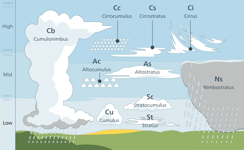
Clouds are identified and categorized by several factors: the altitude of the cloud, the cloud shape, texture, vertical extent, color, and whether or not the cloud is producing precipitation. The World Meteorological Organization (WMO) classifies the height and shape of clouds using Latin prefixes and suffixes. Combine the 3 terms – shape, elevation, and precipitation – and you are cloud conversant.
Clouds described by Elevation
- Cirrus (meaning “wisp of hair”) represent high-altitude clouds high in the sky (above 20,000 feet). These thin, wispy clouds indicate fair weather.
- Alto (meaning “high”) represents mid-altitude clouds (between 6,500 and 20,000 feet).
- There is no prefix for low-altitude clouds (less than 6,500 feet).
- Fog represents clouds that hover near the ground.
Clouds described by Shape
- Cumulus (meaning “heap”) refers to piled-up, lumpy cotton-shaped clouds caused by high humidity and unstable air. Dark cumulus clouds usually bring rain. White cumulus clouds indicate fair weather.
- Stratus (meaning “layer”) refers to featureless, flat layered clouds that form sheets. They tend to develop lower in the sky and cover a large area. They form when warm air pushes across cold air, often resulting in rain.
Clouds described by Precipitating
- Nimbus (meaning “rain”) refers to clouds that can produce precipitation (rain, snow, hail).
2) Wind
Clouds do not always tell the full story of forthcoming weather. You also need to examine the wind. The wind is another useful indicator of bad weather because it is created from disorder in the atmosphere. If the wind suddenly picks up, towering cumulus clouds build vertically and begin to darken, you should consider hiking away from summits and exposed ridge tops.
Nature is all about balance. Regions of excess move toward regions of deficit. As warm air rises, air pressure drops. That is because when air rises, the air molecules move away from the surface causing a low pressure at the surface. The surrounding air moves to the surface to replace the warm air that has risen. The earth tries to balance surface pressure by moving high pressure (colder) air to low pressure (warmer) areas under rain clouds. When these air masses of differing pressures meet, “wind” is created. The wind serves to equalize the pressure between the two different air masses by moving the air away.
3) Pressure
In addition to clouds and wind, a dropping of barometric pressure can identify the likelihood of a storm. A storm is undoubtedly forthcoming when the wind suddenly picks up, dark clouds hover above your head, and the air pressure drops. You should no longer consider descending down a summit, but do it!
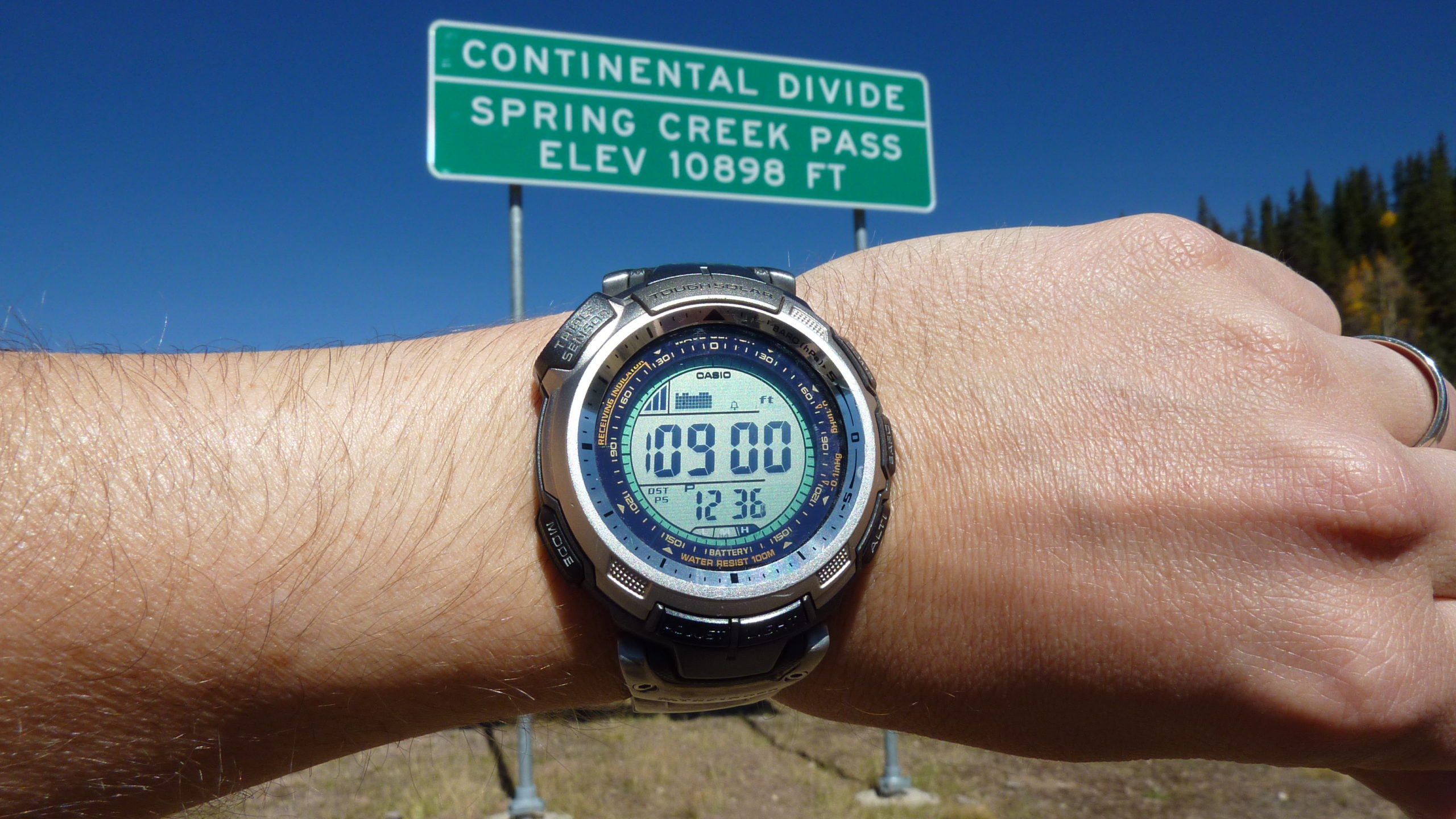
How can you tell if the pressure is dropping? Most altimeters work by measuring barometric pressure. When the barometric pressure rapidly drops, it often means a change for the worst. You can get an indication of these changes by the fact that your elevation suddenly begins to change far more rapidly than the known elevation of the trail. This is not an exact science, though. As altitude increases, atmospheric pressure decreases. But a sudden drop in temperature, such as from a cold front, can make the reading inaccurate. That is because most devices that measure barometric pressure rely on “density altitude” or mass of air which varies based on temperature and humidity.
Not every hiker carries an altimeter with them, and many don’t find a need to do so. However, a barometric altimeter is a pretty simple device, and many multi-function sports watches (i.e., the Casio Solar) and survival knives have this feature. We’ve found the altimeter useful on many occasions because it helps identify your location when used with a topographic map.
Keep in mind that barometric pressure changes with the weather and must be re-calibrated every so often when the altitude is known. Most wilderness areas display the altitude at various trail junctions or atop mountain peaks.
If you have an altimeter, always check the altitude reading to a known altitude printed on a map or trail marking.
GPS altimeters may also work but tend to be less accurate when hiking in areas with a weak satellite signal or hiking deep down in areas such as gorges or canyons.
If you do not have a scientific way to measure barometric pressure, you can look for signs in nature. Birds have a tendency to fly much lower to the ground right before rain due to the thinning of the air. Most people also report having an increased sense of smell. If you are hiking in a damp or swampy area and the air seems to become stinkier or smell like compost, expect rainy weather. That is because swamps and plants release gases as the pressure decreases. Other people can “feel” rain approaching due to an increased sensation of pain in their joints or sinus pressure.
Why pressure changes in response to weather
The weight of the air pressing down on the Earth causes air pressure. The “weight” or amount of Barometric Pressure changes based on several factors, including the air temperature, altitude, and humidity. Cold air has a higher mass than warm air, which creates a different pressure. Low pressure is associated with bad weather because less pressure causes the air to rise. The rising air cools and causes condensation, which releases water in the form of rain.
Weather Lore
Familiarity with weather lore is also helpful for predicting the weather. Not all of these sayings hold true for all circumstances, but many are surprisingly accurate.
Looking at the Moon
- If you can see the dark part of the crescent moon, it means 24 to 48 hours of good weather.
- A ring or halo around the moon (ice cloud) brings rain. By counting the number of stars in the ring, you can fairly accurately predict how long away the rain will be. Each star represents 24 hours, faint star 12 hours.
- If the moon’s face is red, expect rain. The red color is due to the presence of dust being pushed ahead of a low-pressure front, bringing in moisture.
Looking at the Sun
- Red Sky: A red sky at night, hikers delight; Red sky at morning, hikers take warning. Don’t confuse a red sky with a red sun in the morning. If the sun is red and the sky is a normal blue color, the day will be fair.
- Red Sun: A red sun at dusk or dawn indicates fair weather.
- If you see a rainbow or white band around the sun, expect a drastic change in the weather within 12-24 hours. If the weather is currently clear, plan on stormy weather; if dreary, plan on clear weather.
Looking at Rainbows
- Rainbows in the morning to the west indicate approaching rain.
- A rainbow at sunset indicates rain is leaving, and fair weather is on the way.
Looking at Wildlife
Birds and insects tend to fly much lower to the ground before rain due to the thinning of the air. If you have a campfire, you’ll also notice the smoke hovers nearer to the ground for the same reason.
- Flies are more active before rain.
- Birds fly lower before rain.
- Most songbirds tend to sing less before a storm, although Robins often get more vocal before rain.
- Ants and spiders become more active before rain. Frogs, cicadas, and crickets get louder before rain.
- Cows tend to lay down before rain and stay close together.
Look at Plants
- Flowers bloom in fair weather and close up when rain is approaching.
- Dry grass in the morning signals rain in the afternoon. “Dew on the grass, rain will never come to pass.”
- Pliable pine cones indicate forthcoming rain or recent rain. In dry weather, pine cones are stiff, and the scales open out. When it is damp, the scales absorb moisture and become flexible.
Learning how to read cloud formations is a useful wilderness skill because clouds are a good indicator of approaching weather. Cell phones and other electronic devices are not always useful or reliable in remote wilderness areas because forecasting is often imprecise or irrelevant for your exact location. And as the Earth’s atmosphere warms up due to the increased concentration of greenhouse gases, it brings about a greater frequency of extreme weather events. Taking the time to understand how the weather happens can help you prepare for these sudden storms. Now that you understand how all of this works, you are a knowledgeable weather observer.